
The alert
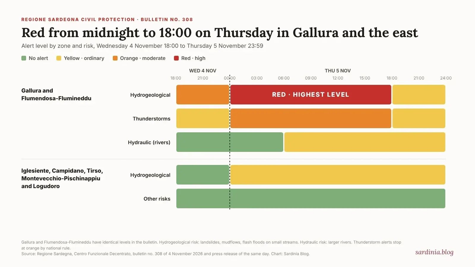
The Centro Funzionale of Sardinia's regional civil protection issued bulletin no. 308 on Wednesday 4 November, with a press release signed by director general Mauro Merella. The warning runs from 18:00 on Wednesday to 23:59 on Thursday 5 November. Hour by hour, the bulletin sets:
Gallura and Flumendosa-Flumineddu, hydrogeological risk: orange from 18:00 to midnight on Wednesday, red from midnight to 18:00 on Thursday, yellow from 18:00 to midnight on Thursday
The same two zones, thunderstorm risk: yellow on Wednesday evening, orange from midnight to 18:00 on Thursday, then yellow
The same two zones, hydraulic risk (rivers): yellow from about 06:00 on Thursday
Iglesiente, Campidano (which includes Cagliari), Montevecchio-Pischinappiu, Tirso and Logudoro: yellow for hydrogeological risk from midnight on Thursday
The two red zones cover the east of the island, from Olbia and the Gallura coast through Baronia down to Ogliastra and Sarrabus. Olbia.it and Teleregione were first to report the red code. The chart at the top of this item shows the alert hour by hour. Full-size versions: the hour-by-hour timeline and our table of what each colour code means; both are also in a companion post.
What a red alert means
Italy uses one colour scale for weather and flood warnings, set out by the national civil protection department in its guidance on alert levels and event scenarios. Each colour is tied to a level of criticità and to the damage expected:
Yellow (criticità ordinaria): localised landslides, mudflows and flooding of small streams. «Occasionale pericolo per la sicurezza delle persone» (occasional danger to people, with possible loss of life through accidents).
Orange (criticità moderata): widespread landslides and flooding, damage to buildings, roads and bridges. «Pericolo per la sicurezza delle persone con possibili perdite di vite umane» (danger to people, with possible loss of life).
Red (criticità elevata): numerous or extensive landslides and mudflows, large rises in small streams with extensive flooding, bridges blocked by debris, buildings and roads damaged or destroyed, both near and far from watercourses. «Grave pericolo per la sicurezza delle persone con possibili perdite di vite umane» (serious danger to people, with possible loss of life).
Thunderstorms only go up to orange. The guidance explains that at red level storms are already part of the intense, widespread rain that defines the red hydrogeological scenario, with the same effects. It also says thunderstorm forecasts carry high uncertainty on place, timing and intensity: very heavy downpours can hit small areas in a short time.
Any alert, even yellow, obliges each mayor to activate the procedures in the comune's emergency plan. Each mayor decides whether to open the centro operativo comunale (COC), the local emergency operations centre, and what to close. The bulletin sets the operational phase for both red zones at preallarme, the stage before full alarm, and at attenzione, the first stage, in the five yellow zones. Olbia and Golfo Aranci have both activated their COC.
Closures for Thursday 5 November
Olbia: all schools of every level, nurseries, play centres, social centres and socio-educational services, plus Parco Fausto Noce and the city cemeteries, Gallura Oggi reported.
Golfo Aranci: «Scuole, palestre, cimitero e parchi saranno chiusi» (schools, gyms, the cemetery and parks will be closed), mayor Giuseppe Fasolino said. Ordinance no. 32 also asks residents to limit travel within the comune and warns that further measures are possible, Olbia.it reported. The COC was being activated on Wednesday afternoon.
Budoni: ordinance no. 30 closes all schools including the asilo nido, parks, sports facilities and cemeteries; cemeteries stay open only for burials and mortuary services, Olbia.it reported.
Posada, Torpè and Orosei have also closed schools, according to Fanpage, whose list was still being updated.
Other comuni were still signing ordinances on Wednesday afternoon. Check your own comune's website or social pages before Thursday morning. As of about 16:00 on Wednesday we found no reports of cancelled ferries or flights.
The forecast
ARPAS, the regional environmental agency, forecasts cloudy to overcast skies on Thursday, especially in the east, with scattered to widespread showers and thunderstorms, L'Unione Sarda reported. Strong thunderstorms are possible in the east, especially between Ogliastra and Baronia, and ARPAS expects locally very high rain totals in the east. Winds will be light to moderate from the east, with gusts up to gale force during storms, and the sea rough to locally very rough. The official bulletin gives no rainfall figures.
The last time: Cyclone Harry in January
Gallura and Flumendosa-Flumineddu were last on red for hydrogeological risk on 19 and 20 January 2026, during Cyclone Harry; the region extended the red code by 24 hours on 19 January, MeteoWeb reported.
Olbia closed all schools, public and private, including nurseries and 0 to 3 services, plus Parco Fausto Noce and the cemeteries. Arzachena, Palau, Santa Teresa Gallura and Loiri Porto San Paolo also closed schools, and ASL Gallura shut its offices and outpatient services for a day, keeping urgent care open, L'Unione Sarda reported. Mayor Settimo Nizzi said: «La sicurezza dei cittadini viene prima di tutto» (citizens' safety comes first).
Firefighters cleared roads blocked by fallen branches and poles in Olbia, the Via Amba Alagi underpass stayed closed, a basement flooded in Arzachena, Palau and La Maddalena were linked by a single ferry and the early Santa Teresa–Bonifacio crossing was cancelled, L'Unione Sarda reported.
A year earlier, on 18 January 2025, a red alert in the east led Nuoro and Tortolì to close schools, Sky TG24 reported. Not every alert closes schools: in February 2026, for a wind warning, Olbia closed only Parco Fausto Noce and the cemeteries, MeteoWeb reported.
Gallura's caution has a history. On 18 November 2013 Cyclone Cleopatra killed 19 people in Sardinia, nine of them in Olbia and four in Arzachena, L'Unione Sarda recalled last year. An expert report ordered by the appeal court in the trial over six of the Olbia deaths found that the flood was neither exceptional nor unpredictable for a Mediterranean autumn, L'Unione Sarda reported in 2022.
How to prepare tonight
The regional civil protection's self-protection guide for floods advises:
Find out whether your street or building is in a flood-prone area. Your comune's emergency plan lists these areas, escape routes and emergency assembly points; holiday guests can ask their host.
Move the car to higher ground before the rain starts, away from canals, riverbanks and underpasses
Take valuables, documents and anything you need out of cellars, basements and garages now, not during the storm
Protect ground-floor doors with boards or sandbags, and close cellar and garage doors only if you can do it safely
Keep within easy reach: copies of documents, a first-aid kit, bottled water, food that keeps, a change of clothes, a torch, a battery radio and rubber boots, and make sure everyone at home knows where they are
Check how your comune sends alerts, on its website, social pages or app, and keep following them
Do not sleep in basement rooms. If someone in the household needs help to move, make sure neighbours or the comune know.
During the storm
Indoors:
Do not go down to the cellar, basement or garage to save belongings, and do not go out to move the car once the water is rising
If you are on the ground floor or below, go upstairs. Avoid the lift.
Switch off gas, electricity and heating, and do not touch electrical equipment with wet hands
Do not drink tap water during flooding, as it could be contaminated, and keep phone calls short so lines stay free
Outdoors:
Do not cross flooded streams, on foot or in any vehicle, and do not stop on bridges, riverbanks or in underpasses
Moving water a few centimetres deep can knock you over, and a car can float in little more than 30 centimetres of water, the regional guide warns. Never drive into moving water or a flooded underpass, even on a road you know.
Head for higher ground, but away from steep slopes and embankments that could slide, and watch for open manholes and holes in the road
In a thunderstorm, keep off beaches and piers and out of the water, and do not shelter under trees, the regional thunderstorm guide adds
Olbia.it's alert report also advises drivers to slow down and pull over somewhere safe during the heaviest downpours. Emergency numbers: 112 for all emergencies, 115 for the fire brigade, 118 for medical emergencies, 1515 for the regional forest and environment corps.
Visitors and travel
Visitors with ferries or flights on Thursday should check with the operator before setting off and allow extra time on the roads to Olbia's port and airport, which may be slowed by flooding or fallen trees. Hikers should postpone walks in the hills and gorges of Gallura, Baronia and Ogliastra until the alert ends. Our earlier forecast note covers the wider weather pattern.
A note on the alert
Alert levels can be raised, lowered or extended; the regional civil protection publishes each new bulletin on the SardegnaAmbiente portal. The closures listed above are those reported by about 16:00 on Wednesday. The meaning of each colour comes from the national guidance; the regional bulletin applies it to each alert zone. Some reports quote rainfall estimates from weather models; we have not used them because the official bulletin gives no figures. We will update this item if the alert changes.
Chart: Sardinia Blog, from regional civil protection bulletin no. 308.
Sources: Regione Sardegna civil protection, bulletin no. 308, 4 November 2026 · Regione Sardegna civil protection, press release, 4 November 2026 · Dipartimento della Protezione Civile, alert levels and event scenarios · Regione Sardegna, self-protection in case of flood · Regione Sardegna, self-protection in thunderstorms · Olbia.it, 4 November 2026 · Teleregione, 4 November 2026 · Gallura Oggi, 4 November 2026 · Olbia.it, Golfo Aranci, 4 November 2026 · Olbia.it, Budoni, 4 November 2026 · Fanpage, 4 November 2026 · L'Unione Sarda, 4 November 2026 · L'Unione Sarda, 19 January 2026 · MeteoWeb, 19 January 2026 · L'Unione Sarda, 20 January 2026 · MeteoWeb, 19 February 2026 · Sky TG24, 17 January 2025 · L'Unione Sarda, 18 November 2025 · L'Unione Sarda, 13 April 2022
Related reading
Elsewhere on Sardinia Blog: our earlier forecast of the bad weather wave; the first snow on Bruncu Spina; and the plan to dredge Olbia's harbour.
Sardinia Blog is published within the Rental12 ecosystem, an owner-operator letting homes it owns in Olbia and Golfo Aranci. Its own Olbia weather page and its press archive are company statements, not independent evidence.